Mapping and surveying and expropriation map construction for the Light Rail’s Green Line project.
Mapping and surveying and expropriation maps construction for the Light Rail’s Green Line project.
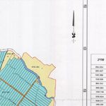
The Green Line of Light Rail project is executed for the NTA. The company prepared the declaration map of the southern, central and northern sections of the Green Line. Its’ route includes the section between Rishon LeZion and Bat Yam, the Holon junction, Pinchas Lavon St., Mount Zion avenue , Ibn Gvirol, Bechor Shitrit, Raoul Wallenberg, through the Sde Dov area up until the Hertzilya border. Datamap Group accompanies all stages of the expropriation process, constructing the land owner’s protocols and providing consultation services. Part of the project included field marketing for fencing purposes based on field measurements. Datamap group was an integral part of the project. The planning stage included photogrammetric mapping of each route at a 1:5000 scale and completing any concealed areas. As part of the process, an infrastructure survey was also conducted.